Hurricane Season Cruising: What You Need to Know Before You Go


Considering a hurricane season cruise to the Caribbean, Bahamas, Bermuda, Mexican Riviera or even Canada and New England? Whether you want to know when the hurricane season is in the Caribbean or how cruises can be affected by these storms, we have the facts you need for your next cruise.
First things first: the chances your cruise will be affected by a storm in hurricane season are slim. However, changes to your itinerary are possible, and it's important to approach a hurricane season cruise with the right attitude.
With that in mind, we've put together the things you'll need to know to book your vacation during hurricane season with confidence.
When Is the Atlantic Hurricane Season?

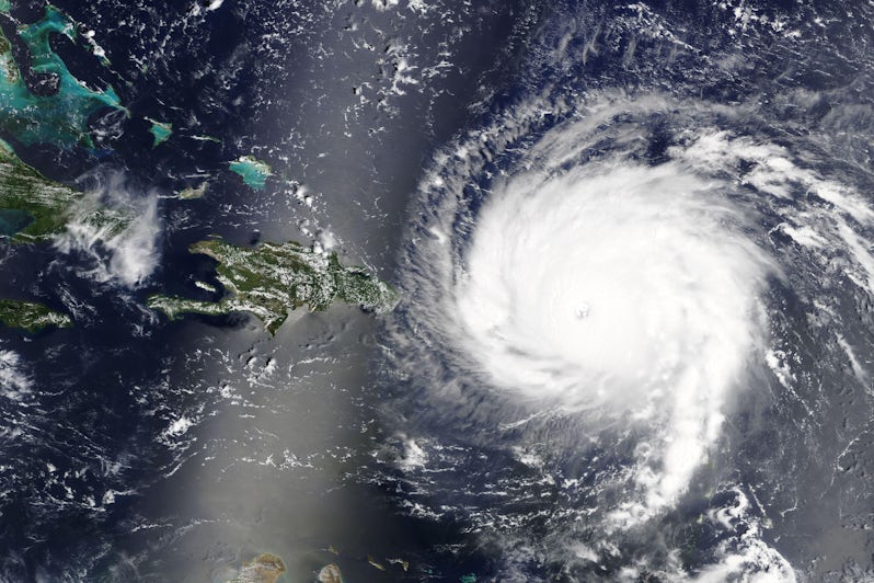
Hurricane season in the Caribbean, Gulf of Mexico and Atlantic Ocean officially runs from June 1 through November 30.
Although the exact paths and initial development of individual hurricanes are hard to predict, the season is generally busiest between mid-August and mid-September. In the Western Caribbean (including the Riviera Maya in Mexico), storms are more frequent from mid-September into early November.
In the Atlantic and Eastern Pacific regions, an average hurricane season typically involves 14 named storms, seven hurricanes and three major hurricanes (major hurricanes are Category 3, 4 or 5 on the Saffir-Simpson Scale), according to the National Hurricane Center.
When Is Hurricane Season in the Caribbean?
This now begs the question when is hurricane season in the Caribbean? Since Caribbean hurricanes are part of the Atlantic hurricane season, the Caribbean hurricane season runs from June 1 to November 30.
Key Tips for Hurricane Season Cruises
Look for a cruise deal: Cruise deals and discounts abound during hurricane season, particularly in the peak period between mid-July and early October.
Just remember, this is not the time to book a vacation if you’re set on visiting one particular port or are planning a cruise destination event. That Western Caribbean cruise you booked may turn into an Eastern Caribbean voyage with entirely different ports of call or more sea days. Booking a cruise during the hurricane season in the Caribbean offers great deals to cruisers.
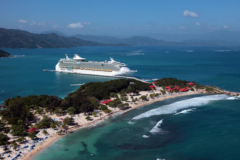
Be flexible: Many Caribbean cruises depart from South Florida and San Juan, Puerto Rico -- both of which are frequent hurricane targets. Consider booking a cruise vacation from an alternative embarkation port outside of these zones during hurricane season.
Keep in mind that airports in these regions can also be affected by severe weather. Hurricanes in the Caribbean seasons are often easy to track, so finding a hurricane-free embarkation area should be simple.
Buy travel insurance: Whether you obtain travel insurance through the cruise line or through an independent provider, travel insurance is essential for hurricane season cruises. Make sure the travel insurance policy covers disruption in case of weather-related events.
It’s important to be prepared for the worst, especially if you know you’re booking a cruise during the Caribbean hurricane season.
Hurricane Season Cruising: How Safe Are Cruise Ships During Hurricanes?
Cruise lines avoid rather than confront hurricanes. With their long history in the Caribbean, all lines have effective hurricane and tropical storm emergency response plans in place. These plans are well-rehearsed by crew and cruise line personnel, not that you’d ever know as you’re tucking into a prime steak or sipping on a cocktail.
Emergency response plans include outfitting ships with state-of-the-art satellites, designating a bridge officer as the weather monitor during the hurricane season and backing up onboard efforts with expanded staff at headquarters. You should always follow cruise safety tips to have the best experience onboard.
The biggest challenge if a hurricane disrupts a cruise is finding alternate places to dock or anchor when ships' scheduled ports of call are threatened.
The most common solution is a simple geographical switch. A ship whose Eastern Caribbean itinerary appears to be in flux will be moved to the Western Caribbean (and vice versa). And if new port calls can't be assured, the schedule may end up including a couple of extra sea days in calmer waters. This means that most cruisers won’t have to miss out on any fun even if they do travel during hurricane season in the Caribbean.
Do you get compensated for missed ports? No. The fine print in your cruise contract gives lines the right to substitute and/or eliminate ports if and when necessary. However, you may be entitled to refunds on prepaid port taxes or fees when ports are missed.
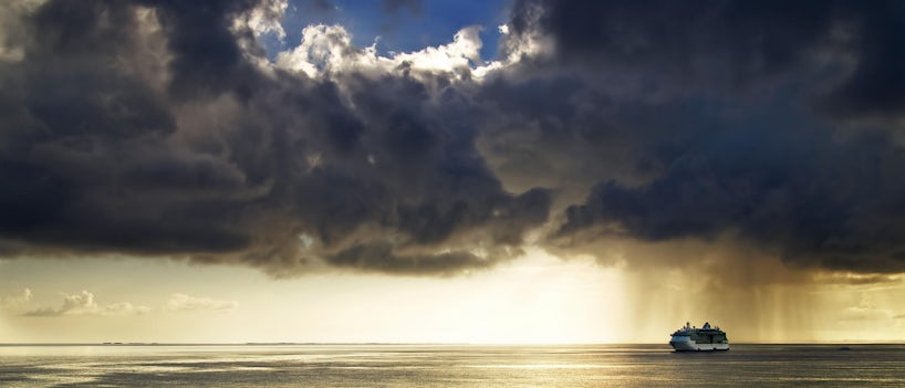
Even Cruise Ships Outrunning a Storm Can Encounter Rough Waters
While increasingly sophisticated technology and mechanics can help ships evade storms, they can't avoid them entirely; rougher-than-usual waters are often found far from a hurricane itself. You may even experience storm remnants where you least expect to, such as on North Atlantic repositioning cruises coming out of Europe.
When the threat of a storm occurs, cruise ships can outsail them. Storms tend to move at about 8 to 10 knots, while ships can attain speeds of up to 22 knots and beyond. This can help when storms intensify rapidly while a ship is at sea, but come armed with seasickness medication just in case (and yes, that goes for seasoned cruisers and first-time cruisers alike).
Can a Hurricane Capsize a Cruise Ship?
Cruise lines follow the weather and changes in the weather very closely to track danger. Today cruise ships are built with state-of-the-art technology that helps cruise lines avoid, outrun and prevent disaster.
In theory, a hurricane could capsize a cruise ship, but a quick change in the itinerary or outrunning a hurricane is the solution to avoiding trouble while cruising.
What To Do If You Can't Get to Your Cruise Ship Because of a Hurricane

Sometimes hurricane-related problems don't have anything to do with the ship and everything to do with conditions at the port of embarkation.
As we said before, plan ahead. Build a day or two into your vacation and aim to arrive in port a couple of days early in case difficulties arise. Prepare for the possibility -- and it happens -- that you might actually arrive home a day or two late.
If you're having trouble getting into your port of embarkation, make sure you contact the cruise line (carry their toll-free emergency number in your wallet or save it in your cell phone). Most will do everything possible, even if they are not obligated, to help you get to the ship, but there's no guarantee.
Getting to your ship on time can feel stressful, especially when dealing with the unknowns of inclement weather. Having a plan in place and understanding when hurricane season is in your desired destination(s) means you can enjoy your cruise stress-free.
Do Cruise Lines Cancel Cruises Because of Hurricanes?
Canceled cruises are rare and cruise lines generally opt to change their itineraries instead. Exceptions are generally limited to anticipated direct strikes on major ports of embarkation, like Fort Lauderdale and Miami. Even in such cases, it's an unusual outcome.
More often, departure is delayed by a day or so, and passengers are generally compensated accordingly. If the weather prevents you from getting to your cruise, there are multiple strategies that can help you resolve the issue.
If your cruise is canceled last minute, you will get a refund. You might also receive a discount or free onboard credit on a future cruise.
When Is the Pacific Hurricane Season?

The East Pacific hurricane season is oft-overlooked because there are simply more people cruising in Caribbean hurricanes than on the Mexican Riviera. However, if you are planning a cruise to Hawaii and the western coast of Mexico are also hit by hurricanes and are monitored in just the same manner by weather experts and cruise lines.
Cruises to Australia, New Zealand and parts of East and Southeast Asia deal with cyclones -- and the southern hemisphere's seasonal equivalent is just the opposite of waters found farther north (their season peaks in March and April).
Hurricane Season Cruises: Bottom Line
Start monitoring tropical storm and hurricane conditions a week before you leave. Be proactive if your cruise is in the likely path of a storm by contacting your travel agent or the cruise line directly in case contingency plans are necessary.
Cruising during hurricane season may actually be advantageous with some excellent deals and often fewer crowds. Just remember to follow all of your cruise line’s onboard procedures and, in the safety of calmer waters, have fun.